


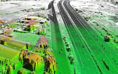
LiDAR data elaboration
Based on a deep knowledge of both Terrestrial and Airborne LiDAR systems and a strong know-how in GIS and image processing techniques, e-laser is able to exploit these technologies in a deeper way, furnishing basic and advanced features. Our company works by using the state-of-the art software for the geographical data management and implements proprietary methods and algorithms for filtering and classifying LiDAR data.
Digital Surface Models (DSMs)
Digital Surface Model is a well known topographic elevation model of the earth surface that contains both anthropical features (buildings, roads, vegetation) as well as natural features (terrain, vegetation, landscape). This models can be detected through different remote sensing techniques such as photogrammetry, Satellite remote sensing, IfSAR, LiDAR but also through field survey campaigns. Among these techniques, LiDAR provides full 3D Surfaces by surveying point cloud of 3 dimensional coordinates that can be used in order to create 3D fly-through, simulated environments, decision support systems and to perform viewshed analysis.
 Top of page
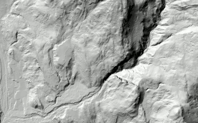
Digital Terrain Models (DTMs)
Digital Terrain Models generally represent a subset of the earth surface in which the above ground elements (vegetation, buildings, bridges, etc) are excluded, obtaining the so-called "bare-earth model". LiDAR system furnishes precise information on the terrain morphology also in correspondence of dense vegetated areas, thanks to the capacity of the laser beam to penetrate the forestry cover, reaching the ground. Using specific automatic and semi-automatic algorithms, e-laser is able to produce very high precision terrain models from the raw LiDAR point cloud, providing the outputting DTM in a number of different standard formats. The DTM is used for geological and hydrological applications, drainage modeling, land-use studies, GIS basic layer and more.
Top of page
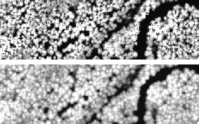
Crown Height Models (CHMs)
The Crown Height Model is a widely used vegetation index allowing the automatic estimation of the forest height, the forest cover and, in the case of multi-temporal surveyed data, the detection of the forestry cover changes. This index can be obtained by an algebraic subtraction between the rasterized Digital Surface Model and the Digital Terrain Model. e-laser implemented an original method that enables the removal of vegetation intermediate echoes from the LiDAR dataset. This improvement represents a step forward for the production of very high quality CHMs.
Top of page
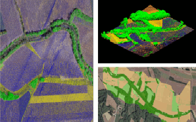
Land use
The intensity of the return signal is an important source of information available from LiDAR data, useful for thematic classification of the surface, the object detection and the vegetation species characterization. In this context, particularly powerful is the LiDAR data fusion with orthophotos, thermal scannings or hyperspectral data, making it possible the combination of geometrical and material-related information. e-laser makes use of these technologies to elaborate accurate GIS cartographies for land use and land use changes assessment.
Top of page